Having driven to Queenstown late on Friday night, we spent Saturday morning picking up the tickets and essential gear (sleeping bags and walking poles) we were hiring from a particularly well-equipped outdoor-activities shop, and splashing out on the odd piece of walking goodies to make our trip more comfortable. Then we caught our bus for the 90 minute ride out of Queenstown that would take us to the start of the route, stopping en-route to take in the incredible views over
 Shortly after 2pm we were on the trail, which started with gentle gradients and frequent river crossings on wobbly swinging bridges over the Route Burn. We stopped for the first proper rest at the edge of the Routeburn Flats, on the bank of the river looking over this pretty valley floor. From here, the path climbed steadily through a beech forest and across avalanche paths where the trees had been ripped away in the slips, and small rocks lay strewn across the path, larger boulders resting precariously on the slope below.
Before too long we'd made it to the hut where we were staying for the night. These are very different to Scottish bothies or some of the bunkhouses attached to campsites in the UK I've stayed in before, and instead these are modern, well designed and built buildings maintained and (in the Summer) permanently staffed by NZ's Department of Conservation. This hut had two partitioned rooms of 24 bunks, a large combined kitchen and dining room with plenty of gas hobs and sinks for running water - most impressively, it also had flush toilets!  And of course, it also came with tremendous views into the valley; a few steps away was the
And then the piece de la resistance...accompanied by the customary singing from us and several other trampers, Jo brought out a lemon and poppy seed muffin (carefully packed for the journey) with a candle on top to serve as Pamela's birthday cake. Well done Jo for sacrificing valuable space and weight -  unfortunately a bottle of champagne wouldn't have travelled so well, so it was washed down with a mug of tea instead! Like all proper camping trips, we played cards until late before heading to bed when the lights were switched off. And then, like all proper camping trips, sleep was restless and broken by neighbouring snoring and then daybreak at 5am.
6 January
The next day we were treated again to more beautiful weather. After forcing down instant 'creamy porridge', we set off on the day's trek, climbing up past the waterfall and above the tree line into sub-alpine vegetation such as ferns and cushion plants. The climb lasted about an hour and  a half up to the adjacent
 Returning to Pamela after our detour, we set off again skirting the Hollyford valley for a couple of hours before our first sighting of
  ush plants and flowers we'd spent the rest of the day walking amongst.
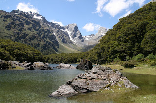
At last we made it to the hut, which was in the most beautiful setting at the end of  hallow water, and later Pamela and I trekked round the side of the lake, fighting through dense trees and brush until we tumbled out of the forest at the head of the lake to see the reciprocal lake views. On the return journey, we also took in a viewing of 'split rock' which is - as I think you can guess - a large rock, split its full height, such that you can see daylight between. In typical NZ superlative style, it's probably a 'world famous' split in the rock, but not too much to see here!
Back at the hut, after another cracking dinner,  the hut warden appeared, to give a part familiarisation/safety briefing, part stand-up routine. This was all jovial, until he mentioned the 'severe weather warning for the next day...
7 January
Early attempts to keep our feet dry were soon all for naught, as the streams we had to cross (strengthening with the extra rainfall) soon made the path their bed to became streams we had to wade through.
Compared to the previous day, there was little to see apart from the mist, but after walking through the 'Orchard' ("an open grassy area dotted with ribbonwood trees" according to the guidebook) we could see four impressive waterfalls in the distance. We soon realised though that these would eventually need to be crossed, and we were aware that not all of the rivers had bridges. The biggest waterfall - Earland Falls - had an 'escape route' with a bridge lower down the hill, but we ignored this and gingerly approached the face of the falls nevertheless: initially just to get a close look at the monster, but then we supposed it should be possible to cross in front of it on the original path. As we walked in front of the landing zone for all that powerful water, the spray itself created a strong wind that buffeted us as we crossed the narrow bridge over the torrent and the spray somehow infused every piece of clothing - seemingly even through our waterproofs - to ensure we were thoroughly drenched. The rest of the rivers were crossed by wading through, with much concentration and use of walking poles to ensure our footing wasn't swept away, but in truth, we weren't at any real risk at any point.
We stopped at a shelter for a while, where we knew there was only another hour's walk to go, so we didn't change clothes despite the diminishing rain. I nstead we just ate lunch and dripped over the seats and floor for a while, before venturing back into our waterproofs and out into the elements. We ate up the remaining kilometres in a quick hike that let us to the shelter at the Divide, where we joined 20 or so other earlier arrivals to wait for their bus pick-ups. At last we could change into our remaining dry clothes and eat our remaining food. For some reason, the others had managed to book earlier buses to their destinations, so we were left at the shelter for longest, with nothing to do but play cards, swat sand flies, and reflect on a classic walk, full of variety and challenge, whilst still providing a wonderful level of comfort.
Finally our bus to Te Anau arrived, and we sat dotted amongst exhausted, moody tourists, who were ending their full-day trip to


No comments:
Post a Comment